More room for urban climate – identifying heat islands and enabling problem-solving at an early stage

More room for urban climate – identifying heat islands and enabling problem-solving at an early stage
Our current project is defining the possibilities of an area in the Limmattal. Starting with a temporary partial use, our aim is to create, in the long term, space for urban living and working, as well as quiet open spaces.
The planning credit for the elaboration and project planning of the lakeshore upgrading was approved in a vote by the people of Arth. A working group under the lead of SEILER & SEILER developed the process and the overall project vision.
A new research publication of the FH OST and HSLU formulates model processes for inner development projects. One of the cited best practice examples is the project of lakeshore renewal in the city of Arth, which we supervise.
An existing location with an extensive range of health / "living in old age" services in the canton of Zurich is to be expanded in the coming years. For this purpose SEILER & SEILER developed comprehensive urban planning studies.
SEILER & SEILER participated in the competition for ideas regarding the "Stadthotel Triemli". Ideas were sought for further (re-)use of three former high-rise staff houses of the city hospital Triemli.
Our team developed a new 3D print process to easily produce urban working models.
A consortium lead by SEILER & SEILER will elaborate various urban planning studies for the Federal Office for Buildings and Logistics BBL. The contract runs from January 2023.
SEILER & SEILER supports a municipality in the Canton of Zurich in the process of elaborating a new building and zoning code.
SEILER & SEILER and esri further strengthen their long-standing and established cooperation.
SEILER & SEILER elaborates a new investment process for the city of Biel.
SEILER & SEILER is supervising a medium-scale planner selection process for several new residential buildings in the Zurich region.
SEILER & SEILER supports the city of Wil in its search for new school locations with several feasibility studies.
SEILER & SEILER is giving the topic of urban climate more room. As of now, we are able to simulate the impact of urban development projects on urban climate, allowing to identify heat islands and enabling problem-solving at an early stage.
SEILER & SEILER is compensating its CO2-emissions of 2020 with the foundation myclimate. The emissions will be compensated by at least 50% in Swiss climate protection projects, the remaining part in developing / threshold countries. From now on, we also use 100% nature made power to support the production of green electricity in Switzerland.
By order of the Canton of Zurich, SEILER & SEILER develops a model for the estimation of the existing floor area per building within the Canton's borders. The model is a key component for the estimation of the urban densification potential for the entire Canton.
In the Arth-Goldau urban development plan, several sub-projects reach an important milestone with the public disclosure of several land use plans. A new main access road as well as campus and area developments create space for jobs, tourism, culture or education directly adjacent to the Arth-Goldau train station. More
By order of the Canton of Zurich, SEILER & SEILER develops a model for the calculation of the maximum allowable floor area per parcel in building zones. The model is a key component for the capacity analysis of building zones and for the model for settlement of excess value.
More clearly, simpler and with direct access to the virtual meeting room. Design by Büro 146, implementation by Bänziger Hug.
Zug Estates and the City of Zug are presenting initial results of the joint planning process for the Metalli area. SEILER & SEILER has accompanied the first phase with planning agreement and process organization. Learn more.
At Swissbau Focus, Roman Seiler will provide insight into how digital tools support urban planners and architects in estimating potentials of urban densification. A collaboration with HSR - Unversity of Applied Sciences Rapperswil. Swissbau Focus 15/01/2020. Learn more.
SEILER & SEILER supports the Mobility Office of the Canton of Basel City in its communication with the public about the tram network development. For example, with an animated video about the next stages of the extension.
A working group under the lead of SEILER & SEILER is compiling feasibility studies in the strategic project phase for the Swiss Federal Department of Economic Affairs, Education, and Research. Starting in January of 2019 on behalf of the Federal Office for Buildings and Logistics.
The lightning talks of the First European CityEngine User Meeting in Copenhagen are now online. Learn more about the urban densification tool from SEILER & SEILER and other fascinating CityEngine use cases.
Our colleagues at vrbn are organizing the first European CityEngine User Meeting in Copenhagen on the 30th of March. SEILER & SEILER will have a talk about one of the most pressing topics in Urban Planning in Switzerland – Increasing Urban Density – and how CityEngine helps us to tackle it.
SEILER & SEILER deals with the methodological revision and updating of the importance plan of public spaces for the city of Zürich.
A Smart 3D City Model from SEILER & SEILER is used for the new high-rise concept of Birsfelden.
SEILER & SEILER is working on the planning of a health resort on the Fontana property in Chur and determines the development structure, public space concept and access system that are best suited for a well-balanced urbanistic, economic and functional development.
SEILER & SEILER supports the Department of Mobility, Canton of Basel-Stadt, in the communication on the tram network development.
SEILER & SEILER was invited to present the Smart 3D City Models to a larger group of selected decision makers at the Innovation Day of the University of Applied Sciences Rapperswil.
On behalf of the Regional Planning Office of the two Basel SEILER & SEILER is analyzing the current and future extent of the core city of Basel. SEILER & SEILER's GIS-Wizard for building zone capacity assessment is applied in this mandate to estimate the future development of the core city.
The CityEngine tutorial created by SEILER & SEILER and Matthias Buehler is now published on the Esri Website. The tutorial introduces promising applications for 3D modeling in the field of urban planning.
SEILER & SEILER has finished the first project phase - assessment of the potential of a new train station. The next project phase - participation - is about to start.
You want to reach sound decisions on your own development project more quickly and easily? Use the Smart 3D City Model from SEILER & SEILER.
SEILER & SEILER is giving a presentation on the topic 'Urban Development with 3D Technology' at the 8th UNIGIS Day Switzerland together with ESRI and deliver a first insight into the features of their Masterplan Rules for CityEngine.
The court has ruled: the construction of a residential project on the outskirts of Zurich can be started. SEILER & SEILER contributed to this success with the service URBAN OPTIMISATION.
SEILER & SEILER is working on a feasibility study on integrated urban development for the city of Khujand, Tajikistan.
SEILER & SEILER is developing an Urban Design tutorial for CityEngine in collaboration with Esri R&D Zurich. The tutorial demonstrates promising prospects of procedural modeling in the field of Urban Planning and Design. Contact us to learn more about this innovative tool.
The decision has been taken after a two-stage pre-qualification: SEILER & SEILER advises the municipality of Wetzikon on the master planning of the city center. In collaboration with plan77.
SEILER & SEILER is engaged in the development of concepts for integrated urban infrastructure projects.
SEILER & SEILER, in collaboration with helsinkizurich, is working on the enhancement of the base concept for a global business area at Zurich Airport.
Bruno Seiler has joined the operational business. He enhances SEILER & SEILER's range of services with GIS Analysis and Mapping.
SEILER & SEILER has submitted a development concept to the open international competition on a block in the historical center of Belgorod, Russia. A collaboration with Manukyan Architects, Moscow.
SEILER & SEILER, in collaboration with plan77, has been short listed for a Regional Planning mandate in a prospering part of Switzerland.
SEILER & SEILER has transformed a vision, conceived in spring 2012 for a 16 ha parcel of land within the Zurich Metropolitan Area, into the basis for a master plan.
SEILER & SEILER is working on a project, which involves 80 housing units from the 1940s, where the aim is the preservation of the iconic characteristics whilst discretely bringing it in line with more contemporary requirements.
SEILER & SEILER is working on the transformation of a part of the city centre of Bern as well as being involved in realising a plan for an area near the Lake of Zurich, in Schmerikon SG.
A honorable mention was given to the concept for a contemporary park by SEILER & ZEHNDER. Vinnitsa, with 370'000 inhabitants, is the biggest central-Ukrainian city. An open competition was hold about the development of the 35ha Gorky Park in the citycenter.
SEILER & SEILER is developing a first Phyton-based GIS toolbox for spatial planning-use.
SEILER & SEILER is thinking about a vision for a large site in the metropolitan area of Zurich.
The mayor of Berlin Kreuzberg-Friedrichshain supports the development concept Zapf of SEILER & thespacebetweenpeople.
SEILER & SEILER works on scenarios for an urban extension in the metropolitan area of Zurich.
Around forty international teams participated at the open masterplan competition in Andermatt CH. Among the five winning masterplans is the one of SEILER & helsinkizurich.
The municipality of Zurich uses the service 'Quick urbanistic idea' for decision-making.
An entry for better cities, as part of the European 11 competition, is on the way.
First developer uses the service 'urbanistic optimisation' for a building project of higher value.
SEILER & SEILER is selected on the shortlist in a international planning and architectural competition.
SEILER & SEILER works on an urban layout for an area beside the river Spree in Berlin DE.
SEILER & SEILER is participating in prequalifications for development areas in Unterägeri CH and ЛУКИНО RU.
SEILER & SEILER works on solutions for an urban extension in Chur. The city of Chur is located in the Swiss Alps, about 100km southeast of Zurich. The competition lasts until the end of the year.
Get a decision making basis for planning processes as quickly and comprehensively as never seen before. The models produced by urban modeling are as vivid as conventional city models. However, they are dynamic and can be updated in real time. We combine urban modeling seamlessly with established processes such as development plans and master plans in order to accelerate development. The Smart 3D City Models, a planning tool developed by SEILER & SEILER, forms the basis for this.
Development concepts bring new ideas for areas, neighborhoods or districts. They provide property owners, architects, developers and authorities a decision making basis to launch a longer-term development. We design visions, scenarios or concepts from participatory processes or directly from the desktop in close coordination with the client.
Spatial data are an indispensable basis for supporting strategic decisions. They help companies, developers and authorities with an overview of complex point of departures and derive strategic objectives. We are experts in spatial analysis and answer questions about the state of development and the contexts of spatial patterns. SEILER & SEILER develops Wizards, GIS-based planning tools for more efficient analysis of spatial data.
Master plans point to a gradual implementation of development concepts and ideas. They guide landowners, developers and authorities to strategic objectives. We show what concrete steps are necessary and take over tasks from project management to the creation of special land use plans and master plans.

SEILER & SEILER are specialists in urban development (form and object) and strategic urban planning (infrastructure, locations and coverage). We employ new smart tools (GIS-Wizards, smart 3D city models) which are updated continuously with additional features.
Our customers include:
City of Zurich, City of Winterthur, Canton of Basel – Stadt, Canton of Zurich, Swiss State Secretariat for Economic Affairs as well as various real estate developers.
ROMAN SEILER
Roman Seiler *1978 is an urbanist. He develops spatial ideas and accompanies them through the strategic project phase. He combines his experience in research and his long-standing practice in the private and public sector. He facilitates the development of public spaces, high-rises, infrastructure works, masterplans, urban densification projects and more. In addition, he dedicates himself to the development of digital urban planning tools since the foundation of SEILER & SEILER.
BRUNO SEILER
Bruno Seiler *1981 is a geographer. He specializes in the analysis and modeling of spatial data. He has acquired experience in a range of industries and companies, from start-up to big corporation, from reinsurance industry to software development to urban planning. Apart from working with state-of-the-art GIS-technology he also focuses on the development of digital urban planning tools.
Get a decision making basis for planning processes as quickly and comprehensively as never seen before. The models produced by urban modeling are as vivid as conventional city models. However, they are dynamic and can be updated in real time. We combine urban modeling seamlessly with established processes such as development plans and master plans in order to accelerate development. The Smart 3D City Models, a planning tool developed by SEILER & SEILER, forms the basis for this.
Development concepts bring new ideas for areas, neighborhoods or districts. They provide property owners, architects, developers and authorities a decision making basis to launch a longer-term development. We design visions, scenarios or concepts from participatory processes or directly from the desktop in close coordination with the client.
Spatial data are an indispensable basis for supporting strategic decisions. They help companies, developers and authorities with an overview of complex point of departures and derive strategic objectives. We are experts in spatial analysis and answer questions about the state of development and the contexts of spatial patterns. SEILER & SEILER develops Wizards, GIS-based planning tools for more efficient analysis of spatial data.
Master plans point to a gradual implementation of development concepts and ideas. They guide landowners, developers and authorities to strategic objectives. We show what concrete steps are necessary and take over tasks from project management to the creation of special land use plans and master plans.
SEILER & SEILER are specialists in urban development (form and object) and strategic urban planning (infrastructure, locations and coverage). We employ new smart tools (GIS-Wizards, smart 3D city models) which are updated continuously with additional features.
Our customers include:
City of Zurich, City of Winterthur, Canton of Basel – Stadt, Canton of Zurich, Swiss State Secretariat for Economic Affairs as well as various real estate developers.
ROMAN SEILER
Roman Seiler *1978 is an urbanist. He develops spatial ideas and accompanies them through the strategic project phase. He combines his experience in research and his long-standing practice in the private and public sector. He facilitates the development of public spaces, high-rises, infrastructure works, masterplans, urban densification projects and more. In addition, he dedicates himself to the development of digital urban planning tools since the foundation of SEILER & SEILER.
BRUNO SEILER
Bruno Seiler *1981 is a geographer. He specializes in the analysis and modeling of spatial data. He has acquired experience in a range of industries and companies, from start-up to big corporation, from reinsurance industry to software development to urban planning. Apart from working with state-of-the-art GIS-technology he also focuses on the development of digital urban planning tools.
SEILER & SEILER
+41 44 586 21 48
Gutstrasse 173
CH-8047 Zürich
mail@seilerseiler.com
ROMAN SEILER
+41 44 586 21 48
rs@seilerseiler.com
BRUNO SEILER
+41 44 586 02 12
bs@seilerseiler.com
RETO LUCEK
+41 44 586 05 23
rl@seilerseiler.com
MICHAEL PFISTER
+41 44 586 45 33
mp@seilerseiler.com
Via the New Transalpine Railway (NEAT), Arth-Goldau will become the first train stop between southern and northern Switzerland. A master plan is required to prepare the area around the the railway station for this enhanced site quality. It is developed in a stakeholder process involving property owners, representatives of the local population, representatives of industry and commerce, and public authorities.
The site developer is kicking off the discussion and communicating the master plan with a Smart 3D City Model by SEILER & SEILER. The model is developed by the planner in a remarkably short time with a new digital tool. The tool visualizes potential densification and combines maximal building volume with parameters, like the building height or floor area. Design aids assist with the selection of relevant sites and with the efficient fine tuning of building volume.
| Category | Smart 3D City Model |
| Area | 35 ha |
| Features | Densification Potential, Smart Zoning |
| Type | Commission |
| Client | Public |
| Partner | Hochschule Rapperswil, Urban Development Department IRAP (Lead) |
| Status | Ongoing |

The Capacity Wizard allows automated and rapid identification of potential areas for urban densification. The results are used as a basis for specific area developments or revision of land-use plans. The Wizard allows more time for the election of the decisive parameters and the detailed analysis of the results and also guarantees consistent results.
The Capacity Wizard detects the current situation and calculates the capacity of construction zones with respect to construction volume, floor space, population and employment. These figures are calculated automatically for a selected area, yet important parameters such as densification rate or potential volume requirement per inhabitant or employee remain varied. The basic data sets used in the calculation can be easily and quickly updated periodically.
The Wizard is an ArcGIS toolbox that has been programmed with Python. A complementary intelligent Excel based tool allows the assumptions to vary independently of ArcGIS and thus it is easy to create and compare different scenarios. The city of Winterthur is using the Wizard as part of the overall revision of the land-use plan.
| Category | Urban Planning, GIS Analysis and Mapping |
| Type | Commission |
| Client | Public |
| Status | Completed |
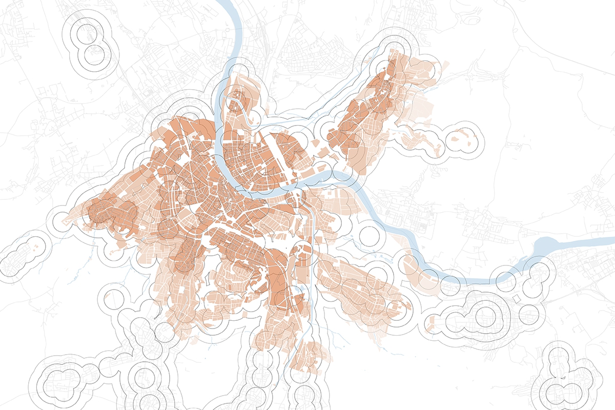
The city of Basel and its neighboring municipalities have become an agglomeration and accordingly, already today the transition from city border to neighboring municipality cannot be precisely determined by visual means anymore. Therefore, an analysis of the character and the extent of the core city of Basel independently of institutional borders was conducted on behalf of seven municipalities and under the leadership of the regional planning authority of Basel-Stadt and Basel-Landschaft.
In a first step, the quantitative partial indicators that determine the urban character of a spatial entity were identified and calculated: population density, availability of public spaces, variety of uses, construction density and accessibility by public transport. From these indicators, the current extent of the core city of Basel was deduced by means of an overall model. In addition, potential spaces that could achieve core city character within the next 20 years were identified. To this end, higher-level planning instruments such as the high-rise concept were evaluated, with the densification potential included as an additional factor.
The results of the study will be used by the affected communities as a basis for discussion for future regional planning issues spanning several municipalities or cantons and indicate areas for cooperation in the core city region.
| Category | Urban Planning, GIS Analysis / Mapping |
| Type | Study with Prequalification |
| Client | Public |
| Partner | raumplan wirz |
| Status | Completed |

Khujand is located on the Silk Road in the North of Tajikistan. With a population of 170’000 the city is an important centre of economy and education of the country.
An analysis of Khujand city and its state of urban planning was performed on behalf of the State Secretariat for Economic Affairs SECO. This study serves SECO as a basis for formulating the subsequent project which intends to strengthen the urban planning processes in Khujand. During a field mission to Khujand the project team conducted interviews with the city administration, NGOs, international financing institutions and civic bodies, studied essential documents and inspected various city quarters and infrastructural elements.
The results are composed of an analysis of the structure, issues and challenges of the city as for example natural hazards. In addition the state of urban planning is outlined with a focus on planning fundamentals, instruments, process, stakeholders and financing. The study concludes with recommendations about how the integrated urban planning project can be realised, with sketches of the most promising ideas.
| Category | Urban Planning |
| Type | Commission |
| Client | Public |
| Partner | plan77 |
| Status | Completed |

The area known as First District is situated on the outskirts to the north of the Agglomeration Zurich, in close proximity to the Zurich Airport. It follows a line of large employment-providing areas between the Zurich City Centre and the Airport.
The Urban Development Framework highlights various possibilities for optimally utilising the various key access points to the area. It also develops a concept for the recreational spaces that surround the built-up areas. These recreational spaces will serve to guide the visitor through the area and are designed in such a way that all three areas are connected. There is a good mix in the recreational areas between activity and tranquility zones, without necessarily disadvantaging any of the developments by their proximity to one or the other zones. The composition of the building parcels have also been analysed in terms of the type of structures to be erected and presented in the form of various options. The concept shows various possiblities for improving the traffic infrastructure and also considers various aboveground and subterranean options for connecting the two areas to the southern area. The regional railway (S-Bahn) stop can be progressively transformed into an iconic symbol for the whole area.
The insights from this concept will serve as the basis for discussions with various stakeholders, like the operators of the traffic and transport facilities, political representatives and superordinate specialist departments.
| Category | Urban Planning / Development |
| Type | Commission |
| Client | Private |
| Partners | helsinkizurich, plan77 |
| Status | Completed |

Gotzenwil is situated on a pastoral hillside on the outskirts of Winterthur. There are 2 smaller settlements close by.
The City and Canton have decided to pursue a modest urban development in the Gotzenwil area. The urban framework will consider different development scenarios, taking into account the environmental impact, and a possible staged approach to developing the area. The urban development framework shows the delimitations and possibilities for future development.
The attractive location, on a rise above the city, is particularly ideal for families. The trend towards an ever aging population in Gotzenwil will be negated by the influx of families taking up residence in the family-sized apartments that will be built there. At the same time, accommodation types more suitable for older people would also encourage the older generations to downsize, allowing families to move into existing houses that have been vacated this way. The study will also show the interrelationship between the expansion of the public transport offering and traffic-reduced or high density developments.
| Area | 390'000 m2 |
| Density | 0.8 |
| Category | Urban Planning |
| Type | Commission |
| Client | Public |
| Partners | Esch Sintzel Architekten, Rotzler Krebs Landschaftsarchitekten, Raumdaten |
| Status | Completed |

Schmerikon is located at the upper end of the Lake of Zurich. The town centre, with many small shops, extends along the main street. The area in question is situated within close proximity and within view of the shoreline. A 19‘500m2 parcel of land will form the basis for a development concept for a new residential area. The concept addresses the questions related to the optimal building density of the area and the number of floors per building, various options concerning the foundations, the location and distribution of the building volume, assignment of parking spaces and the design of the exterior space in the form of a garden. To arrive at the optimal design, various typologies and densities have been considered. The findings of the development concept will flow into a master plan that will be binding for the property owners.
| Area | 18'500 m2 |
| Floor Area | 17'800 m2 |
| Construction Plots | 5 |
| Density | 0.91 |
| Stakeholders | 4 |
| Category | Urban Planning / Development |
| Type | Commission |
| Client | Public / Private |
| Status | Completed |

The area known as First District is situated on the outskirts to the north of the Agglomeration Zurich, in close proximity to the Zurich Airport. It is made up of three areas formed by the freeway and the regional railway (S-Bahn). It follows a line of large employment-providing areas between the Zurich City Centre and the Airport. The vision that has been created identifies a great potential for a Global Business Area. The usuage mix includes office space as well as retail space to cover the daily shopping needs. The biggest challenge later in the development process will be to unite the 3 areas. The vision supports the decision making of the contracting entity. It shows how the land should be envisioned and where investing in a brand would make sense. It also shows the challenges to be faced in the development.
| Category | Urban Development |
| Type | Commission |
| Client | Private |
| Partner | plan77 |
| Status | Completed |

Vinnitsa is a Ukrainian economic and education centre with about 370‘000 inhabitants. Gorky Park lies in the centre of the city and is characterised by its dense forest, diverse offerings and its close proximity to the city centre.
Gorky Park will be transformed into a sophisticated City Park. The use of parallel paths running north to south intersected by parallel paths running east to west will allow the park to communicate with the city centre and be an integral part of it. It will also make orientation easier and give an indication of its size. The character of the park will be defined by four areas: representation, sport, spectacle, and leisure forest.
The Vinnitsa City Park has the best qualities to provide for leisure and recreational activities. The infusion of city life in the park and the transformed view over the park from the fringes, will make this a sought after address for businesses, hotels and apartments. Not only will the park ensure quality of life for future generations, it will also be a driving force in the development of Vinnitsa.
| Area | 350'000 m2 |
| Category | Urban Development |
| Type | Public International Competition |
| Client | Public |
| Partner | Simon Zehnder, Zurich |
| Status | Honorable Mention, Continuation Possible |

Andermatt is located in a barren valley high in the Swiss Alps. The new centre will serve as a link between the old and the new village sectors. At the same time it will also serve as a transportation hub for the Glacier Express, local public transport and the regional PostBus service. The new centre is designed with funnel-shaped promenades linking the railway station, the ski plaza and the sports centre with each other. An alpine park, situated to the north west of the centre, will provide leisure and recreation activities within close proximity of the resort. The layout of the town centre is clearly arranged and makes for easy orientation, which was also a defining characteristic of the old village centre.
| Area | 47'500 m2 |
| Floor Area | 45'000 m2 |
| Construction Plots | 7 |
| Density | 0.9 |
| Category | Urban Development |
| Type | Public International two Stage Competition |
| Client | Private / Public |
| Partners | helsinkizurich, Raumdaten |
| Status | one of five awarded concepts |

With the development of the area on the northern outskirts of the city, two different parts of the city are connected in a mixture of commercial and public facilities and housing. The area along the main artery encloses a smaller city district centre, consisting of structures for commercial use on the ground floor, a public open space and an individual building of high architectural quality. The individual building replaces a historical ensemble and, together with the basic urban structure, it creates a striking entrance to the city.
| Area | 55'000 m2 |
| Floor Area | 61'000 m2 |
| Residents | 800 |
| Construction Plots | 8 |
| Density | 1.1 |
| Category | Urban Development |
| Type | Test Planning on Invitation |
| Client | Public |
| Partners | Haag, Van de Wetering |
| Status | Completed |

This project looks at developing an urban extension on the southern outskirts of Baden at the point of transition into the suburban area of the city. The area is presently used for agricultural purposes and does not benefit too much from its proximity to the city. By 2020 a new living quarter will provide housing for 1300 inhabitants. The development concept comprises two to four storey buildings with about 500 units. A large meadow has been set aside as a recreational and leisure space.
| Area | 160'000 m2 |
| Floor Area | 90'000 m2 |
| Inhabitants | 1'300 |
| Workplaces | 100 |
| Category | Urban Planning / Development |
| Type | Competition with Prequalification |
| Client | Public |
| Partners | Van de Wetering, Hänggi Basler, MRS, Naturaqua |
| Status | First Place, Master Plan in Process |
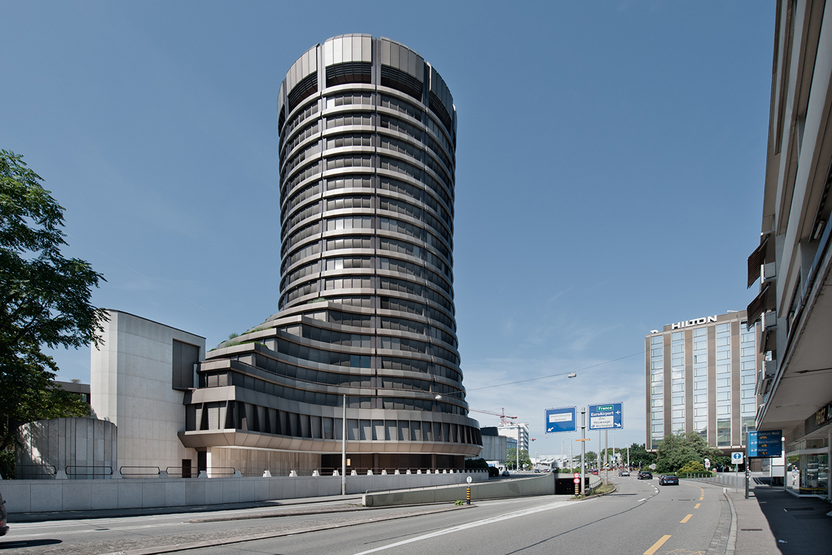
High rise buildings in Basel City are concentrated around the areas of the railway station and the pharmaceutical and life science companies to the north of the city. Basel is located in the north-western part of Switzerland and borders on France and Germany. With the concept ‘High Rise’, Basel City is actively looking into locations for the location of future high rise buildings. The concept not only considers buildings for commercial usage, like the Bank for International Settlements building, but includes buildings for residential usage, particularly along the banks of the Rhine River.
| Number of High Rises today | 100 |
| Suitable Areas | 10 |
| Areas with Potential | 7 |
| Category | Urban Planning |
| Type | Consulting / Illustration, Commission |
| Client | Public |
| Status | Completed |

The Metalli area is located in a prominent position in the center of Zug city, east of the railway station. It covers a focal point of retail trade and is of great importance for the further development of Zug city. As part of a well-developed inner development area of the cantonal master plan and with the high-rise regulation, diverse possibilities open up.
With a competition procedure for the Metalli area, the objectives for a sustainable center were explored:
– Utilization of the inner development potentials, compatible structural densification.
– Implementation in stages. Each step must be urbanistically coherent and enable a functioning center operation.
– Securing and renewing publicly accessible spaces of high stay quality.
– Improved networking for pedestrians.
The process support included drafting a planning agreement and preparing and conducting a competition procedure with intermediate dialogues. The process carried out laid the foundation for a design plan and construction project planning.
| Category | Process, Competition Procedure |
| Uses | Shopping, Services, Hotel, Residential |
| Geschossfläche | 80'000 m2 / proven potential + 20'000 m2 |
| Client | Public / Private |
| Partner | Michael Hauser |
| Status | Completed |
In the coming years, the Dreirosenanlage in Basel Nord will be heavily utilized as part of the National Road Project 'Rheintunnel.' To strengthen the open space, early efforts are being made to enhance the adjacent Rhine riverbank. Possibilities were explored through a test planning process.
We accompanied the test planning with a digital model of the affected neighborhoods. The browser-based model was created from various data sources.
Teams had the opportunity to simulate complex situations above and below ground, across different cross-sections, and throughout various construction phases. They used model renderings for conceptual representations and cross-sections in their contributions. The evaluation panel was able to discuss the similarities and differences among the various contributions using the model.
| Category | Process, Digital Model |
| Objects | approx. 20'000 |
| Perimeter | 90'000 m2 |
| Construction Phases | 7 |
| Client | Public |
| Status | Completed |